The March run/walk hash, moved up one week to this Saturday, March 11, will begin at 3:30 pm from the parking lot of the Wat Doi Hang Nai, in Doi Hang Nai.
GPS location is Latitude 19°55'1.42"N Longitude 99°45'46.98"E
You are welcome to meet at the MalaBar on Jed Yod Rd. at 2:45 if you want to caravan or get a ride to the hash starting point. If you want to go it alone, here are the directions:
You are welcome to meet at the MalaBar on Jed Yod Rd. at 2:45 if you want to caravan or get a ride to the hash starting point. If you want to go it alone, here are the directions:
Leaving Chiang Rai via the Walking Street (Thanalai Road which turns into the Old Chiang Mai Road/Thanon Rat Yotha/Rt. 1211), heading southwest out of town, turn right at the second traffic light in Den Har, onto Soi Honglee Road (the last traffic light going out of town).
Head north, past Chiang Rai Saddlebags, past the Hp Badminton Court. At the intersection, (first picture below), stay to the Left; the police station will be on your R; do not follow the road to the R to the Chiang Rai Women’s prison; doing the hash in predicted 97 degree F (36 C) temperatures will be punishment enough.
Follow the blue signs directing you to the Doi In Cee Stupa. At the next Y (second pic), 6.4 km from the Den Har intersection, bear Left. (Don't strain your neck!)
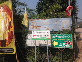
In about 1 km, you will see the Doihang School on your Right; turn Left (road unnamed), following signs for the Doi In Cee Stupa (last picture). In less than 1 km, the parking lot will be on your L, across from the Wat Doi Hang Nai.
If you have any questions about directions, call Lois (Many-men-a-night), at 06-1714-7052.


No comments:
Post a Comment